Pages

Showing posts with label Ohio Valley. Show all posts

Friday, February 23, 2018

How High is the Water, Mama?

That old Johnny Cash song comes to mind today as we watch the flood levels on the Ohio River.

The Ohio River yesterday evening, when the river was at 28.6 feet

Yesterday while we were working at our Marietta booth we were told by the owner that there is a possibility of water actually getting into the building--about 2 feet of water--if the river rises to worst level currently predicted.

What to do? Nothing, really. We moved a few things to higher locations, but we have so much stuff in that mall that moving it all is just not feasible. Even moving some of it isn't. So we will sit tight and watch the weather and river reports.

In the end, it's just stuff. We have more. We can easily restock if it comes to that. What I dread is the cleanup after a flood. I've done that before, once in Virginia helping victims of Hurricane Agnes in 1972, once once when one of the libraries I oversaw got four feet of water. There is no nastier job, I think--slimy mud and dirt all over everything.

The river as of this morning is at 29.6 feet and rising. If it reaches the predicted height of 41 feet, the mall is safe, but if it reaches the outer possibility predicted of 48 feet, there will be 2 feet of water in the building.
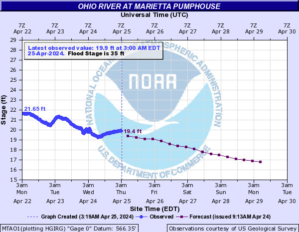
From the National Weather Service website. Click here to view the interactive map.

The problem is that the Ohio drains all the area from the Allegheny mountains to the east to its confluence the Mississippi in the west.

From Wikipedia

As you can see in the above map, the river's basin extends almost to the Great Lakes, and south through Kentucky and Tennessee. And then it joins the Mississippi. The midwest is also getting rain now so that water is coming down the Mississippi and will cause the Ohio to back up even more.
Add in all the other rivers that flow into the Ohio along its route, and there is just a LOT of water all trying to move south.

There is nothing anyone can do about it except wait and watch. And hope that no one loses their home or belongings.

Meanwhile, there's always Johnny Cash...


Copyright Susanna Holstein. All rights reserved. No Republication or Redistribution Allowed without attribution to Susanna Holstein.

Saturday, July 30, 2016

Road Trip: Meigs County, Ohio

We took a break yesterday and went on a little drive over the Ohio River and into Meigs county. We've been through Meigs before but there were a lot of areas we had not yet seen. It's funny how you can live so close to a place but never really know it.

Our first stop was at the Buffington Island Battlefield Park, which also has an Indian mound in its center.


The view from the top of the mound is serene and rural, with cornfields and trees the predominant features.
There are many mounds along the Ohio River, built by the early Native American cultures. This is, I suppose, one of the smaller ones. Many were destroyed by early settlers as they developed cropland.


The Battle of Buffington Island was the largest land battle to take place on Ohio soil, and even as such it was a fairly small affair. I remember attending a re-enactment of the battle in 1997 or 1998 that was held in this park but had not been back to visit since then.


Inside the old stone restrooms, the glass block windows and stonework create interesting patterns.


The road along the river is straight in many places, lined with corn and produce farms. There aren't many houses along here, just quiet, farms and corn. This area is called Long Bottom, with good reason--long, flat stretches of good land.

Further north we spotted another monument, up on a roadbank so we turned around to investigate, and found ourselves standing on a campsite occupied by George Washington in October of 1770, when he was surveying the Ohio Valley.


The view from the site was gorgeous and it was easy to see why Washington elected to camp there: a long view of the river and anyone approaching, and at your back a steep stone cliff that would keep any attackers at bay from that direction. 


This was hostile territory then, and history is filled with stories of attacks and atrocities by both the settlers and the natives.


My favorite house on this side of the river! Isn't it stunning? It looks out across a broad sweep of valley and water.


I can never get enough of looking at the "Beautiful River," although often I think of how many lives were lost trying to navigate its treacherous waters back in the days before the locks and dams tamed it.


We turned west and away from the river finally, and headed into interior Meigs. This bridge crosses the lovely Shade River and is the entrance to the small town of Chester. We did not stop here, or take any photos, although there were several places that looked interesting. We were looking for lunch at this point, and apparently Chester offers no places to eat except a convenience store. Maybe we just missed it.


More of Meigs county in my next post!

Copyright Susanna Holstein. All rights reserved. No Republication or Redistribution Allowed without attribution to Susanna Holstein.
Related Posts Plugin for WordPress, Blogger...